VIS 2026VIS 2026 — Virtual Island Summit|Also: GSIS 2027GSIS 2027
Island Innovation Logo
About
Services
The Network
Events
Content Library
Contact Us

News

Curated stories and analysis from islands and sustainability leaders worldwide.
Loading news...

Subscribe to our newsletter. By submitting, you agree to our Privacy Policy.

Island Innovation

Island Innovation works with governments, institutions, and partners worldwide to support island-led sustainable economic development.

We Support The UN Development Goals

SDG 9: Industry, Innovation and Infrastructure
SDG 11: Sustainable Cities and Communities
SDG 12: Responsible Consumption and Production
SDG 13: Climate Action
SDG 14: Life Below Water
SDG 17: Partnerships for the Goals

Explore

AboutServicesNetworkEvents

Content

ArticlesNewsCareers

Ready to Connect?

Join the island innovation community

Get in Touch

About

  • About us
  • Case Studies
  • FAQs
  • Press
  • Careers
  • Contact

Services

  • Services Overview
  • Public & Media Relations
  • Strategic Communications

Network

  • The Island Network
  • Academic Council
  • Newsletter

Events

  • Our Events
  • Watch Past Events

Content

  • All Content Library
  • Videos
  • Articles
  • News
Privacy PolicyTerms of ServiceContactManage email preferences

© 2025 Island Innovation. All rights reserved.

    Filter by Core Theme

    All ThemesCircular EconomyClimate ActionConnectivity & DigitizationCulture & CommunityEnergy & TransportGreen Finance & EconomyOcean & BiodiversityPolicy & GovernanceTourism & Remote WorkWater & Food
    Showing 9 of 511 news items in Climate Action
    Greenland Glacier Break Creates New Ice Island
    Climate ActionAugust 20, 2026

    Greenland Glacier Break Creates New Ice Island

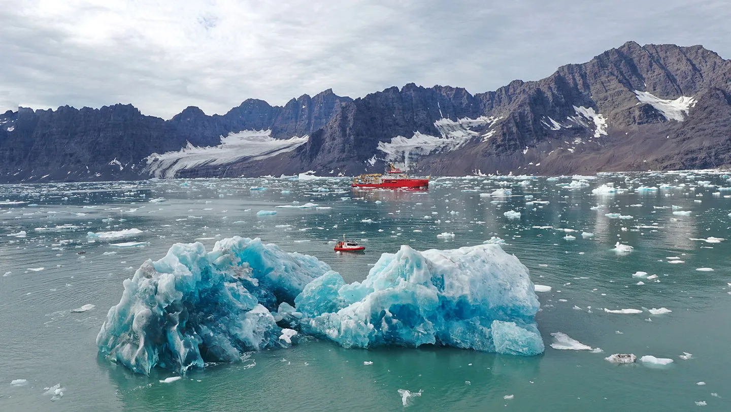
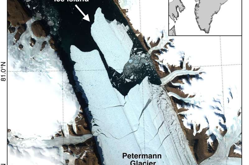
    An international research team partly led by the University of Ottawa reports that Petermann Glacier in northwest Greenland calved a 76.4 km² (29.5 square miles) ice island on Aug. 4, 2026, marking the glacier's largest loss of floating ice since 2012 and the largest Arctic calving event since 2020. The newly formed tabular iceberg detached from the glacier's floating ice tongue and is estimated to be up to 150 meters (492 feet) thick. With a surface area roughly comparable to Manhattan Island, the ice island offers scientists a rare opportunity to study how large Arctic ice masses form, drift and break apart over time. The event was detected by Adam Garbo, a doctoral student in glaciology at uOttawa's Department of Geography, Environment and Geomatics, as part of ongoing collaborations among the University of Ottawa, the University of Stirling, Environment and Climate Change Canada, Lancaster University and the University of Leeds. Years of monitoring helped researchers anticipate the break The calving event was detected through long-term satellite monitoring that has tracked changes at Petermann Glacier since 2019. Researchers have been following the glacier's floating ice tongue, documenting the growth of fractures and monitoring signs of instability over several years. "Petermann Glacier has long been one of Greenland's largest remaining ice tongues," says Garbo. "We've anticipated this break for years, and seeing it finally happen is remarkable." Satellite imagery from the European Space Agency's Sentinel-1 mission showed clear deterioration along the centerline of the ice tongue on Aug. 3. By 20:00 UTC on Aug. 4, the new ice island had detached from the eastern side of the glacier.

    12345678910
    Read more
    Hawaii Could See Its First Hurricane Landfall in Decades as Lala Strengthens
    Climate ActionAugust 20, 2026

    Hawaii Could See Its First Hurricane Landfall in Decades as Lala Strengthens

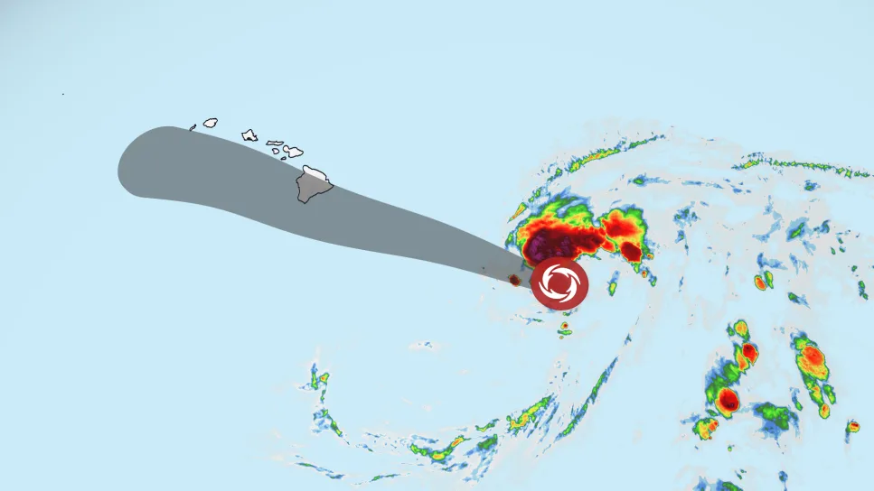
    Hawaii is bracing for a potential hurricane strike this weekend after Tropical Storm Lala’s forecast track shifted north, bringing the strengthening storm — and its heavy rain, damaging winds and dangerous surf — close to the Big Island. A hurricane warning is in effect for Hawaii County, meaning hurricane conditions are expected somewhere on the Big Island by this weekend. A tropical storm warning was issued for Maui County Friday morning, including the islands of Maui, Lanai, Molokai and Kahoolawe. A tropical storm watch was also issued for Oahu and Kauai counties. Lala had sustained winds of 65 mph Friday evening as it moved west-northwest about 260 miles southeast of Hilo, according to the National Hurricane Center. The latest forecast takes Lala near the Big Island on Saturday, raising the possibility of a rare hurricane landfall there. Even a slight shift in its path could determine whether the storm’s center crosses the island or narrowly passes to its south. Regardless, Lala will track close enough to bring strong winds and heavy rain onshore. Hawaii Gov. Josh Green declared a statewide emergency Thursday, allowing officials to activate the National Guard and access emergency funding as the state prepares for Lala. Ahead of the storm, officials in Maui County – where a flood watch is in effect through Sunday – identified temporary evacuation points residents could flee to if conditions worsen. “For Maui County, our main concerns are flash flooding, rapidly rising water in flood-prone areas, and power outages that could leave residents without electricity during the storm,” Mayor Richard Bissen said. “Secure your property, stock up on essentials, prepare for possible power outages, and check on kūpuna (elders), neighbors and loved ones.” Confidence in the exact track should improve through Friday, but there could still be changes as the storm approaches the islands and interacts with land, which can cause its center to wobble.

    Read more
    How Is Climate Change Shaping Tropical Storm Lala?
    Climate ActionAugust 20, 2026

    How Is Climate Change Shaping Tropical Storm Lala?

    Researchers used to believe that Hawaiʻi island acted “like a rock in the stream,” and the winds controlling the movement of tropical storms had to go around it, according to retired University of Hawaiʻi professor Tom Giambelluca, who now oversees the islands’ Mesonet System of weather stations. While the island’s geography – with its 13,000-foot central mountains – does play a key role in protecting parts of the island, the reasons large storms have typically been broken up and slowed before they hit Hawaiʻi are varied and complex. This summer’s supercharged El Niño is largely what’s fueling Tropical Storm Lala, which is expected on Saturday to become the first hurricane to make landfall in Hawai‘i since Iniki in 1992. But scientists say residents should be ready for more storms in the years ahead as the effects of a warming planet take hold in the islands. “I often tell students that El Niño is like a practice run for climate change,” said Alison Nugent, an associate professor at the UH Department of Atmospheric Science, pointing at how climate change is likely to bring more warm temperatures even when the current El Niño cycle is over. In the past, relatively cool ocean temperatures and wind shear — or wind that comes from other directions and disrupts the storm — have both historically been important factors in preventing storms from hitting the islands at hurricane strength. A tropical storm becomes a Category 1 hurricane when winds reach 74-95 miles per hour. Now, as meteorologists have forecast Lala increasing in strength instead of dissipating like the vast majority of storms have in recent decades, it’s raising questions about the impact of climate change. Warmer ocean temperatures are definitely playing a role, Nugent said. Hurricanes get their energy from convection, or latent heat. “When you go from a high-energy state of vapor to a lower energy state of liquid, you release heat, and that heat is what fuels hurricanes,” she said. “With climate change, you have warmer oceans, and therefore the potential to get stronger storms.” Three of the five named storms that have made landfall in Hawai‘i over the last 67 years — Hurricane Dot in 1959, Hurricane Iniki in 1992, Tropical Storm Iselle in 2014, Tropical Storm Darby in 2016 and Tropical Storm Olivia in 2018 — have occurred in the last decade. Climate modeling done in 2016 predicted a significant rise in the number of hurricanes near Hawaiʻi in the coming decades. This year, the warmer-than-usual ocean temperature is playing an important role. If the ocean is below 79 degrees Fahrenheit, a hurricane doesn’t form. If the surface of the ocean hits 80 degrees, it’s a different story. On Thursday, the ocean surface to the south of the islands was between 80.6 and 82.4 degrees Fahrenheit. Exactly how climate change is fueling Lala isn’t entirely clear, however. That’s in part because El Niño — the ocean’s natural warming pattern, which occurs every four to seven years — is also causing significantly warmer temperatures this year. And while some scientists say there’s clear evidence that the climate’s overall warming patterns are supercharging El Niño, that’s still being debated within the scientific community. “The relationship between El Niño and climate change is not well-documented or understood,” said Steven Businger, a professor and former chair of UH’s Atmospheric Sciences Department.

    Read more
    Why Maritime Decarbonisation is the Caribbean’s Next Climate Battleground
    Climate ActionJuly 30, 2026

    Why Maritime Decarbonisation is the Caribbean’s Next Climate Battleground

    For Caribbean Small Island Developing States, decarbonising shipping is a critical economic and climate challenge. The region depends on maritime transport for 80% to 90% of imported food and hosts a large share of global cruise traffic, so poorly designed international measures could raise costs and threaten food security. The University of the West Indies Caribbean Shipping Lanes initiative is building the technical capacity, training and regional coordination needed for Caribbean countries to shape fairer global shipping rules and pursue a resilient low-carbon maritime economy.

    Read more
    Has Greenland Hit a Tipping Point? Scientists Are Listening to the Ice to Find Out
    Climate ActionJuly 30, 2026

    Has Greenland Hit a Tipping Point? Scientists Are Listening to the Ice to Find Out

    Scientists from universities in the United Kingdom and Greenland are studying how meltwater moves through glaciers on Greenland's ice sheet, using passive seismic monitoring to listen to the ice. Their work forms part of the Greenland Runoff Monitoring from Passive Seismology project and aims to improve understanding of how smaller processes across nearly a thousand glaciers add up to sea-level change. The research underscores the global stakes of accelerating Arctic warming and the importance of sustained field science in one of the world's most consequential climate systems.

    Read more
    Too Hot to Work? What Channel Island Laws Say
    Climate ActionJuly 14, 2026

    Too Hot to Work? What Channel Island Laws Say

    A union representing Channel Island workers says it supports the introduction of maximum temperature limits in workplaces to protect staff, as the islands experience their third heatwave of 2026. There is no law in Guernsey, Jersey or the UK that says a given temperature is too hot to work, although each place refers to guidance from the UK's Health and Safety Executive. Temperatures were forecast by Jersey Met to reach up to 34°C, a fortnight after Jersey experienced its hottest day on record at 39.3°C. Unions are calling for stronger protections, risk assessments and practical measures such as ventilation, drinking water, breaks, fans and air-conditioning.

    Read more
    'This Was Something New': What People in Greenland Said About Learning to Live with Wildfires
    Climate ActionJuly 9, 2026

    'This Was Something New': What People in Greenland Said About Learning to Live with Wildfires

    After several quieter years, wildfires have returned to western Greenland. Two recent fires have brought renewed attention to a landscape more typically associated with glaciers and melting ice sheets than flames. But when we visited the region in 2023 to investigate a series of unusual large wildfires that burned a few years earlier, local residents told us they would not be surprised if the fires came back. They remembered how dry the landscape had become before the fires, which made wildfire easier to start and harder to control. For people living around Sisimiut on Greenland's west coast, these latest events are therefore not entirely unexpected. Our research suggests wildfires may be part of a new Arctic reality. During our 2023 fieldwork we spoke to firefighters, local business owners and land-users, tourism managers and international visitors, all of whom had direct experience of the earlier fires. A common thread was that these fires were unlike anything they remembered. Older generations were particularly shocked. As one resident put it, "it was something new, even for us." Their recollections match our own analysis using satellite data and newspaper reports that found no landscape fires in western Greenland from 1995 to 2007, but more than 20 since.

    Read more
    New research uses fibre optic cables to predict glacier loss in Greenland
    Climate ActionApril 30, 2026

    New research uses fibre optic cables to predict glacier loss in Greenland

    Excerpt from dailyuw.com Gradual loss of the Greenland Ice Sheet (GrIS) holds global significance: it exacerbates sea level rise, alters ocean circulation, and threatens Arctic ecosystems. But melt is difficult to quantify. It’s a nonlinear process driven by myriad feedback loops, or reinforced outcomes, and the majority occurs below the ocean’s surface. In the past, GrIS loss monitoring has been limited to computer simulations and Sound Navigation and Ranging (SONAR), which uses sound waves to measure glacier thickness. A 2019 study directed multibeam SONAR at glacier fronts, combined with several other technologies, to simulate a projected loss rate. This projection underestimated ice loss by two orders of magnitude. As glacier loss occurs, the glacier itself is exposed to overall lower elevations, which contain warmer air. This exacerbates melt and creates a positive feedback loop. Still, above surface observations are only 10% of the story. Approximately 90% of GrIS is below the surface, and submarine feedbacks are largely unknown.

    Read more
    Report links human exploitation to climate change
    Climate ActionApril 30, 2026

    Report links human exploitation to climate change

    Excerpt from antiguaobserver.com A new report on the intersection of climate change and human exploitation in Antigua and Barbuda was launched yesterday, revealing how climate-related disasters are creating dangerous vulnerabilities for local communities. The research, conducted by the Commonwealth Human Rights Initiative and Free the Slaves, warns that the loss of livelihoods due to climate impacts is pushing vulnerable populations toward exploitation. Former senator Bakesha Francis James, speaking at the launch, explained the critical connection between environmental crises and human rights violations. “Climate change is often discussed in terms of rising temperatures, extreme weather events and environmental degradation but what is sometimes less visible, yet no less urgent, are human consequences,” Francis James said. “Climate shocks and slow onset environmental changes can deepen existing inequalities, strain livelihoods and increase vulnerability to exploitation including human trafficking and forced labor. These risks are not abstract; they affect real people, real families, and real communities.”

    Read more